
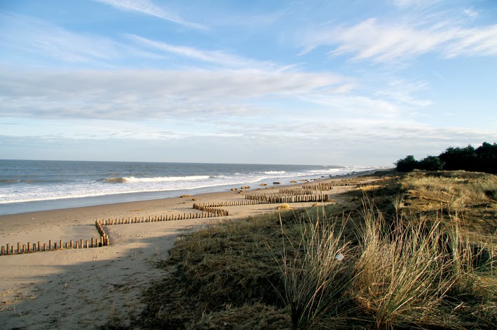
Holme Beach – Calm After The Storm!
I spent the day photographing storm damage along the Norfolk Coast from Holme and as far as Cley. Some of the scenery I saw was amazing and exciting, but some was heartbreaking. The force and intensity of this storm is shocking, but it could have been so much worse. As a friend said this evening, its amazing that there has been no loss of life in Norfolk. My heart goes out to those who have lost their houses and to those people that have suffered flood damage. My account of the day is as follows.
As I left my house, Eddie phoned me to say he was on the West Bank at Cley which was breached in several places, especially by the sluice and the earth from this had collapsed into Beach Road, making this road completely impassable! Eddie had watched a bittern fly over towards Halfway House. The sea watching shelter or 'Beach Hotel' as it is known was still standing as I reported yesterday, but the shingle around it was now loads higher. Eddie has a brilliant picture on facebook showing his tripod/scope standing higher than the shelter!!! Even I wouldn't be able to stand upright in there now!
Holme Reserves
As I had witnessed in the dark on Thursday evening, the aftermath of the sea surge was evident from just past the Hun Bridge along Beach Road, with the road covered in sand and debris. At the entrance to the Firs Road, the railway sleepers from the path to the golfcourse were strewn across the road. These railway sleepers have been there since year dot – so sad to see them dislodged and tossed down the road – I really hope the council place them back. There was a sea pool in the grassy/seated area opposite the toilet block. The path through the golf course has opened up nicely and looks like a ravine! The gate has gone and the fence ripped up. A few mini pools of sea water on the east side of the golf course and large amounts of sand deposited on the west side. There was a wonderful sight west of the path to the main beach gap – a massive lagoon, bang in the middle of the golfcourse complete with Brent Geese and ducks, all looking very at home! A digger was half immersed in the lagoon! It looks so natural and beautiful and as though it should be there! This is payback for pinching some of the land that us locals have walked for years – long story. I smiled and chuckled when I looked at that lagoon! I will pray that the water level stays this high, although I doubt it!
At the beach I bumped into Dave Nurney and friend who pointed out a green wheelie bin on the tide line. We all mused over the fabulous new lagoon! A horse galloped past and there were lots of the usual annoying bouncy dogs on the beach. Left here and walked back to my car. The tidal surge had reached Beach House and other houses to within inches of their doors – very lucky indeed. Drove along the Firs Road and parked up half way down by the carpark/5-bar gate. I stood on the coastal footpath above the carpark and you could see where the sea had trickled over the top!!! (see photo).
Parked on the NOA carpark and walked straight across to the dunes. The dune ridge has been cut back, but not as badly as I first thought. Lots of tidal rubbish and debris. By the Firs beach entrance and further along, there were several uprooted pines. There were pools of sea water in the base of the pines adjacent to the coast footpath and tons of sand and debris covered over the bramble bushes. The path itself was completely churned up, almost all the way to the steps that lead to the observatory. There was clear evidence of the surge reaching the NWT closed/open barrier!!! I walked back to the beach. It was a beautiful, sunny day and the beach looked stunning. I was completely alone, not a dog or another human being in sight – a wonderful and rare experience! I saw one Red-throated Diver and 8 Red-breasted Mergansers flying west. I followed the beach for a long way – I had no choice as the dune ridge is now a cliff!!! I had to walk as far as the lavender marsh, past the Thornham Bank before I could cross the dunes! Tons of plastic and glass bottles piled up. There was a dark green, metal litter bin with 'LITTER' in gold writing by the sea's edge – my guess is that this was from Hunstanton. I walked across the dunes and up onto the Thornham bank and along the boardwalk overlooking the broadwater. Went to the observatory to chat with Sophie, but she wasn't there. I spotted her a few moments later as she did me, walking distantly along the Thornham Bank. Sophie and I caught up later on the telephone. The Firs House and the Observatory were very lucky indeed to not suffer any damage!
Walked to the Firs and had a chat with Warden Gary Hibberd who told me that the sea had broken and trickled over the new sea bank at Thornham!!! Gary also told me he realised that he and his family would have to evacuate on Thursday night when the sea was '16 paces from the dunes' long before high tide! An awful decision to have to make and carry out. A scary thought, knowing that you could lose everything.
Went back to my car and visited my parents and dropped their newspapers in and then continued along the coast.

Holme Golf Course – taken from parking area.

Holme Golf Course, Sand covering the West Side.

Holme Golf Course – Sand covering the East Side.

Holme Golf Course – the now much wider path to the beach.

Erosion of main path through Golf Course.

Erosion of main path through Golf Course.


The magnificent new lagoon on the west side of the Golf Course.

Holme Beach from the main gap through to Golf Course.

Holme Beach from the main gap through to Golf Course.

Erosion of main path through Golf Course.

Erosion of main path through Golf Course.

Erosion of main path through Golf Course.

Erosion of main path through Golf Course.

Erosion of main path through Golf Course.

Sea water in the seated area next to village carpark.

Beach Road covered in sand, opposite the Firs Road and railway sleepers in road.

Beach Road covered in sand, opposite the Firs Road.

Where the surge trickled over the Coastal Footpath!
By the 5-bar gate/carpark, half way along Firs Road.


HOLME BEACH
Between Holme NWT and Thornham Bank.


The coastal Footpath that runs between NWT and NOA and sea water pools in pines.
Staithe Road that leads up to the Coal Barn was a mess of muddy pools and debris. The new sea bank had not withheld the power of the surge! A Little Egret flew over the marsh. I could see the dunes at Titchwell from here and it was obvious from here, that the shape of the landscape had changed! The dune ridge looked lower.
Titchwell RSPB
I only stopped here briefly to buy a book that they didn't have! Spoke to volunteer Tony who said most of the dunes had gone and the boardwalk ripped up. I knew that if I walked out to the sea I wouldn't get to Cley today, so continued on my journey. Someone also told me that Brancaster had lost most of the dunes. Also the seawall at Gypsy Lane, Titchwell had been breached and Holkham Bay was 'a mess'.
Brancaster Staithe
At the harbour (see my photo in previous post) a lorry was pumping out water from the Sailing Club which was flooded out completely and furniture was outside. I could now see that the grass clumps I saw in the dark were in fact stacks of reeds. The footpath which runs west to Brancaster (where last year's arctic warbler was) was officially closed because of flooding.

Brancaster Staithe Quay and flooded Sailing Club House.

West of Brancaster Staithe Quay.

West of the Quay – churned up reed bed, adjacent to the Coastal Footpath.
Burnham Norton
Burnham Norton looked incredible – the entire marshes were flooded right up to the carpark. If you had been looking out of a hide, you would have thought you were at Cley. It was teaming with birds, greylags, brents, wigeon, teal, mute swans, curlews, lapwings, oystercatchers etc etc. A few grassy 'islands' were exposed. This was an awesome site. The path where you walk out across the marsh was non-existent – the metal gate was the only indication that there was a path here! Two blackbirds in the big willow tree.


Burnham Norton Marshes from the carpark.

The gates through the path across the marshes!
On route to Wells I stopped in the layby at Burnham Overy Staithe and had a scan over to Burnham Overy Dunes and Gun Hill. It all looked ok from this distance, but I am sure the dunes would have taken a battering.
Wells and East Hills
Wells Beach Carpark was untouched. I took a risk and didn't pay to park. Walked up the flight of steps and on to the beach. I could not visably see any damage to the beach huts, which I was amazed by, but some of them are when I looked on the net tonight. The small dune ridge in the middle of the beach is now two mini dune clumps!!!


The dune ridge in the middle of the beach at Wells, reduced to two small clumps!

Beach Huts at Wells, almost unscathed!

The Lifeboat Station which suffered water damage at Wells.
I re-parked the car right next to the cafe and walked up to Wells Life Boat Station – did you see the video? From here I was VERY pleased to see that East Hills still existed! To be honest I thought it would have been wrecked, although I could see several fallen pine trees and the dune ridge had been eaten in to – see pictures. Along the beach road near the football pitch, there was a massive flock of Brent Geese in the field.


EAST HILLS
Several fallen pines and dune loss.
Several fallen pines and dune loss.


Brent Geese feeding by the football pitch at Wells.
The quayside at Wells was cordoned off and I could see people trying to sort out the damage to shops and properties. Sand bags remained at some doors. I drove along the road alongside the quay. The light was beautiful now and I spent some time here photographing a juv. Great Black-backed Gull.


Great Black-backed Gull Juv. at Wells Quayside.
On the road to Morston, I stopped to take a picture of the blue Lifeboat house at Blakeney Point – I was pleased to see that this had withstood the storm!

The Lifeboat House still remains at Blakeney Point!
This did however suffer some damage – see the NT Blog.
Blakeney
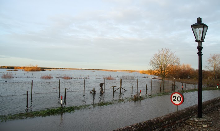
The road down to the quayside was closed. I drove along the road further up, which leads down to the duck pond and Friary Hills. As I approached the bottom corner I could see the road was immersed in reeds and debris. I left my car by the ivy covered wall. The scene before me was a shock! Friary Hills now has a massive lagoon along the bottom path, on which Mute Swans were swimming! The marshes were completely flooded and the duck pond blended in with the flooding. This is no duck pond anymore!!! The waterfowl usually kept here were freely swimming about in the flood – that will cause some excitement if they move around the area! It took me a while to work out what was going on here – the road opposite the duck pond wasn't there - the flood continued over the road to the wall next to the carpark of the hotel! I had to walk through the hotel carpark to access the Blakeney Bank. The main bank has been demolished in several places all the way along, an incredible sight! Two boats were positioned neatly on the top of the coastal path on the bank!!! Tons of reeds and debris next to the toilet block. Several people standing here and in almost disbelief of what they were seeing!

The corner where you park for Friary Hills NT.


Friary Hills NT.


Blakeney Bank – collapsed all the way along.

This boat was perched on the Blakeney Bank Coastal Footpath!

Just opposite where you park for Friary Hills.

Looking towards the duck pond from Friary Hills – the road actually runs where the flood is on the right hand side. The road you think you can see is running through the Manor hotel carpark!!!

Where you park for Friary Hills.


The lower path out across the marshes!

From The Manor Hotel carpark – the road flooded and continues up towards the green tree.

Looking towards Friary Hills - the road actually runs left!

What's left of the Duck Pond!

The Blakeney Bank and boats re-positioned on top!
The lady standing on the bank works in the Cley V.C.


The Duck Pond blending into the flood!


More boats on the bank!

View from the quay with the public toilets on the right.

The flooded road next to The Manor Hotel.

Flood damage.
It was about 3pm by the time I reached Cley which was annoying, but there we go. Following RBA's instructions, at the Cley Deli I turned right, past Cley Church and turned left to follow Old Woman's Lane down to the coast road. The view of the flooded marshes beyond was incredible! The coast road was very wet and muddy in the short drive to the NWT Visitor Centre carpark. The lower carpark was completely flooded and not accessible. The wooden bridge that goes across to the reserve was re-positioned side on, along the verge! The road beyond the Visitor Centre is completely covered with stacks of reeds but is passable just – but I decided not take my car through this. I only had a short amount of time before the light went, so I had to choose between East Bank or the West Bank.


Dauke's, Teal and Avocet NWT Hides – still flooded.


The A149 coast road looking towards Walsey Hills.

The A149 coast road looking towards Cley V.C – East Bank Carpark on right.
I walked from the visitor centre to the East Bank via the NWT path – mistake, the path quickly disappeared and I found myself walking over flattened reeds, scary stuff, don't make the same mistake as me! Crossed over to the road and continued walking to the East Bank carpark. The carpark that is no more – immersed in reed debris. The signs all gone as were all seats.

Snipe's Marsh with tons of reed debris from the reedbeds next to the East Bank.

Snipe's Marsh.

The A149 coast road looking towards Walsey Hills.

The A149 coast road looking towards Walsey Hills.
Tons of reeds fill the road, East Bank carpark, Walsey Hills carpark and Snipe's Marsh.

Walsey Hills NOA Carpark!

Walsey Hills NOA Carpark and Coast Road!

Entrance to Walsey Hills NOA.
The tidal surge just reached the bottom of the steps!

Snipe's Marsh filled with reed debris – from the hide at Walsey Hills NOA.

Looking out from the path at Walsey Hills across the carpark and Arnold's Marsh.


Walsey Hills NOA Carpark.

Sunset over Snipe's Marsh.

Pike – by the roadside near Walsey Hills – victim of the Surge.
The view of Walsey Hills and Snipe's Marsh was incredible. Snipe's marsh was filled with stacks and stacks of reeds from the reedbed west of the East Bank. There was only a small area of the pool left. The carpark at Walsey did not exist. Stacks of reeds covered the road and the carpark in one large area right up to the blue sign for Walsey Hills. The tidal debris had trickled through the bottom public footpath through the bushes, up as far as the bottom of the steps that lead up to the centre and hide. A Cetti's Warbler burst into song, but only briefly and somehow I felt that it sounded so sad! I walked up to the top of the steps to take pictures from a higher view point. Back down on the road by Snipe's Marsh I bumped into Pete Dolton who pointed out a large dead Pike on the verge! Pete had walked Blakeney Point today and had a fascinating and dramatic walk out there. He said that the shingle where all the docks were and the new sueda bushes had gone. He had seen a few dead seal pups but had seen lots of pups alive which is fabulous news! He had watched a mother and pup swimming in a pool in 'The Lupins'!!! Also more pups in a 'new' lagoon east of 'The Plantation'!


East Bank Carpark!


THE EAST BANK.

Eddie Myers & Pete Dolton make their way back along the East Bank.

Eddie Myers & Pete Dolton inspect the damage.
I walked along The East Bank with Pete. There were huge sections of reedbed plonked on the path!!! It was as though a giant had scooped out a massive section of reed bed, roots and mud and then placed it neatly on the top of the path! It was unbelievable to see this. There were several of these massive clumps of reeds in several places along the path and it was a job to get round some of them. I just can't imagine the ferocity of the sea to have done this! If this storm had occurred in daylight, it would have been beyond spectacular to witness. We saw at least 4 Bearded Tits in the remaining reed beds. It was a spectacular sunset with swathes of red streaks filling the horizon from east to west. The light was going fast and at the end of the East Bank we bumped into Eddie who had just walked back along Arnold's Marsh, where he had seen the new cut/channel which had developed at Salthouse! We walked back to the NWT Visitor Centre together in almost complete darkness. Eddie said that one of the home owners along the main road, had found dead harvest mice and bank voles intermingled with the tide debris in their gardens – how very sad. I had a coffee and then drove home. What a day!

Sunset from the East Bank
I can not believe of all the weekends, that I have go to work tomorrow. Not out again until next Saturday. Be careful out there and especially of cliff and dune edges which will be incredibly precarious and dangerous!

Seawatching Shelter at The Leas, Sheringham
PICTURE BY MICK SAUNT
PICTURE BY MICK SAUNT
It's still there, just! Fabulous News! Thanks for the picture Mick!
UPDATE: Mick emailed me on Sunday to say that "the shelter appears 100% ok and on the level. Using a very wide angle lens has made it look tilted backwards (which it isn't!)......"
UPDATE: Mick emailed me on Sunday to say that "the shelter appears 100% ok and on the level. Using a very wide angle lens has made it look tilted backwards (which it isn't!)......"
• Important news from the NT Rangers about Seal Pups HERE
• Update on Seal Pups and Good News for Blakeney Point! HERE
• Mute Swans & Seal Pup swimming along the A149! HERE
• Walcott Carnage! HERE
• Pictures and Updates from other Norfolk Birders HERE
• Unique pictures from Eddie Myers at Cley HERE
• Remains of the hides at Snettisham RSPB HERE and HERE
• Regional Update and Pictures HERE
THANK YOU VERY MUCH TO EVERYONE WHO HAS EMAILED ME
ABOUT THIS POST – IT IS MUCH APPRECIATED.
ABOUT THIS POST – IT IS MUCH APPRECIATED.


my favourite coastline which I have painted for many years, how very very sad it all looks. Now all my paintings will have to change unless I do before and after pics. #Thanks for posting
ReplyDeleteI commend your effort in sharing us the photos of the storm aftermath, Penny. Seeing a house intact is such a relief since you know somehow it was a sanctuary during the storm. This is where reinforcing one's house before a storm plays a major factor. Anyway, thanks again and stay safe! :)
ReplyDeleteJonathan Price @ Jonathan Price
A really awesome and factual report Penny with magnificent pictures of the heartbreaking devastation to that magnificent coastal area. Hard to believe I was in that hide a Snettisham Autumn last year.
DeleteIts so easy to listen to a report but not quite take it in, but seeing it first hand the way you have depicted it here really brings home the destruction nature can wreak upon us.
Thanks Clive!
ReplyDelete